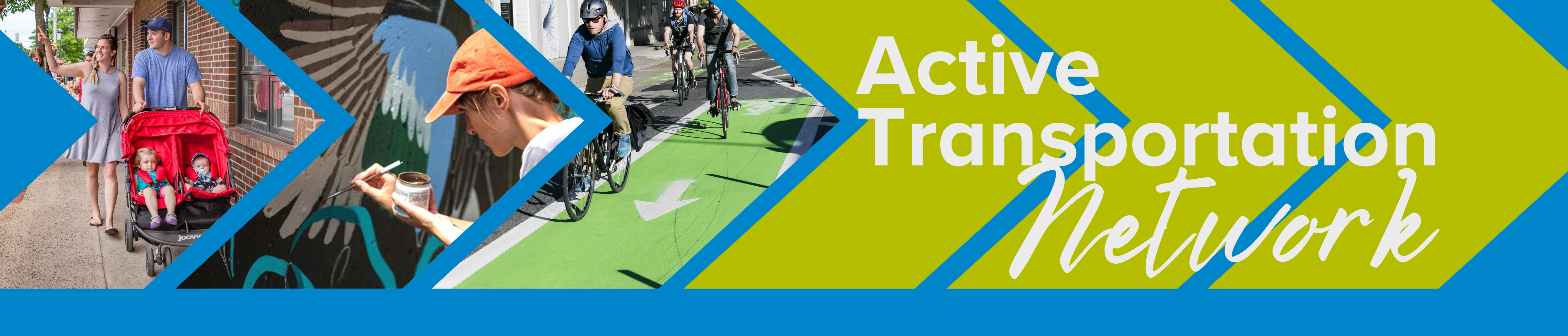
Active Transportation Network
This is your landing page for what construction projects are happening, what you can expect during the work and how it will look when it's finished!
June 2022 Update:
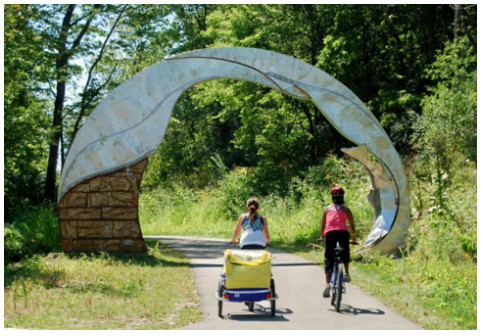
Construction on the downtown active transportation network will start this summer. The following videos show what the path will look like from the east to the west of the downtown route.
"I want more information about construction in my neighbourhood!"
Go to Construction Project Maps (in progress)
"I want to understand the route type that is planned for my neighbourhood!"
Go to AT Route Types
"I want to learn about other amenities the Town is adding!"
Go to Amenities
"I want to learn about the rules of the road!"
Go to Road Safety Provincial Frequently Asked Questions
In the summer of 2021, the Town of Kentville received a grant for active transportation (AT) - it was not for a bike lane or a trail but to make ALL the roads, sidewalks, trails and for programs and amenities easy to use for more active transportation. This grant will allow the Town to implement their entire Kentville Moves Active Transportation Plan over 7 years. The KT Network is a one-of-a-kind project that will result in active transportation as a comfortable and enjoyable part of everyday life in the Town of Kentville for users of all ages, abilities and backgrounds. You can read the full AT plan in the Related Documents section (right).
Kentville's Active Transportation Plan
Active transportation is a broad term that refers to all forms of human powered or non-motorized transportation. This includes walking, the use of assisted devices such as wheelchairs, cycling, and also skateboarding, rollerblading, etc. Seasonal activities like skiing, canoeing, and kayaking are also considered active transportation. Recognizing the importance of safe and enjoyable transportation, the Town has already made many investments into trails and amenities, while this plan will provide an all-encompassing strategy to connect these trails with active transportation facilities. Incorporating education, equity and playfulness into this strategy will ensure that it benefits all users.
This document is the official Active Transportation Plan for the Town of Kentville, which aims to increase and enhance active transportation as a part of everyday life for all residents. The focus of this plan is on improving active transportation corridors and networks over the next 10–15 years.
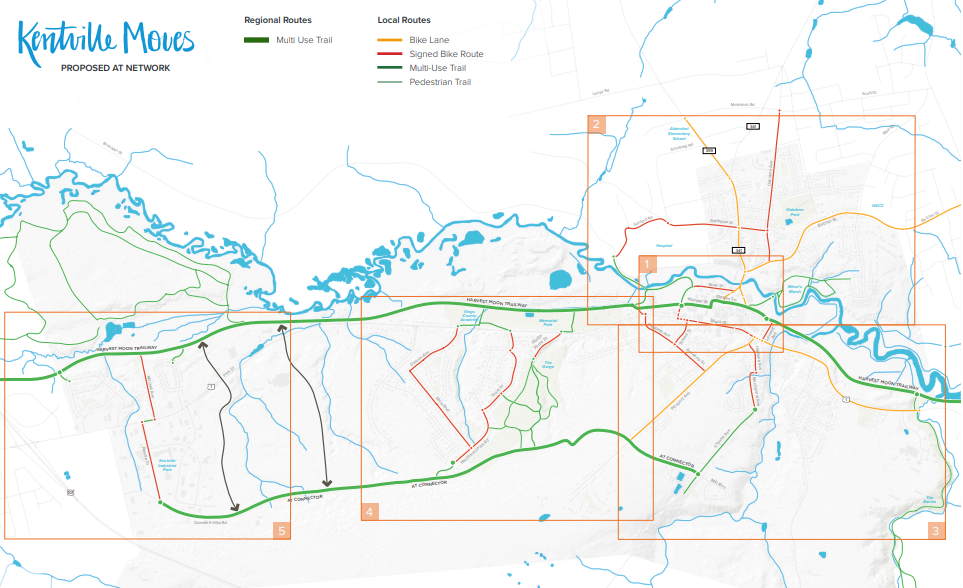
AT Network
There are many different classes of active transportation routes that accommodate different modes, trip types and spatial contexts. The Kentville Active Transportation Network includes signed bike routes, bike lanes, paved shoulders, multi-use pathways, nature trails and more. Each of these route classes can be regional or local route types.
Route Types:
Signed Bike Route
Signed bike routes are designated on-road ‘shared use lanes’, and use signage that indicates that the road is to be shared by motorists and cyclists. Signed bike routes are suitable on lower volume / lower speed roads or in locations where it is important to maintain continuity of a bicycle facility though an area where it is too narrow to fit other active transportation route types. These types of routes should feature “Bike Route” signage, or directional signage that acknowledges that the road is a bike route. For longer distance routes, “Share the Road” signs can also be placed to reinforce that the road must be shared by all road users. Signed bike routes improve the level of comfort for cyclists, but still require a reasonable level of experience and confidence. Novice or beginner riders will likely not be comfortable riding in a shared use lane.
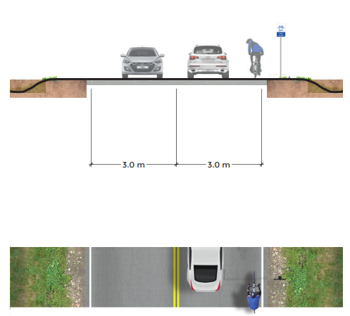
Bicycle Lane
Bicycle lanes provide dedicated space for cyclists alongside vehicular traffic. They improve the level of comfort for cyclists over shared use lanes because they delineate a dedicated space for cyclists. They should be 1.8 metres wide (but must be at least one metre wide) and demarcated with a bicycle stencil placed in the center of the lane. Bike lanes provide a reasonably safe and comfortable cycling facility, particularly on roads with high traffic volumes and speeds. It is important that bicycle lanes stay obstacle-free and are kept clean of snow, ice, litter and debris. It is also important that local law enforcement ensure that bicycle lanes aren’t used for parking or loading. If cars regularly obstruct bike lanes, cyclists are forced to swerve into vehicular lanes, which creates very dangerous situations. There are a handful of on-road active transportation routes within the Town that feature high traffic volumes or are key regional corridors, and should feature bike lanes to allow cyclists to use both sides of the road in a safe and comfortable manner. The cost to develop bike lanes depends on the context. If unused, paved space exists alongside the road already exists, then all that is required is paint and other minor improvements. However, if the shoulders need to be paved, the costs can go up considerably. Furthermore, if on-street parking needs to be removed to accommodate a bike lane, costs could include relocating the parking spaces elsewhere.
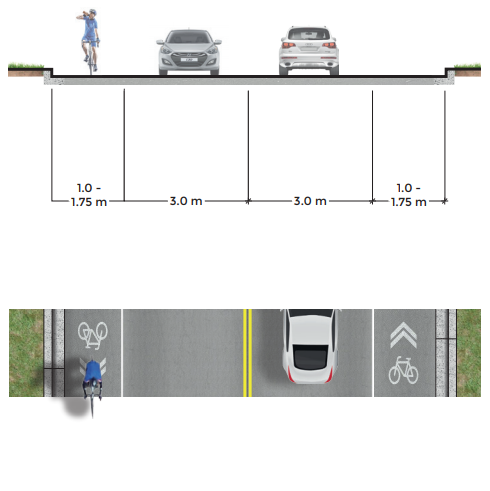
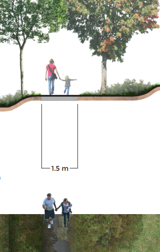
Separated Multi Use Pathway
Separated multi-use trails are located along a road right-of-way and are offered in lieu of a sidewalk and bike lane combination. They can accommodate a variety of active transportation users, including pedestrians and cyclists in the summer, and cross country skiers, and snowshoers. Cyclists and pedestrians can usually share these trails without conflict, however if the number of users grow, the trail width should be increased to 4.5 m and pedestrian and bike paths should be separated by a line.
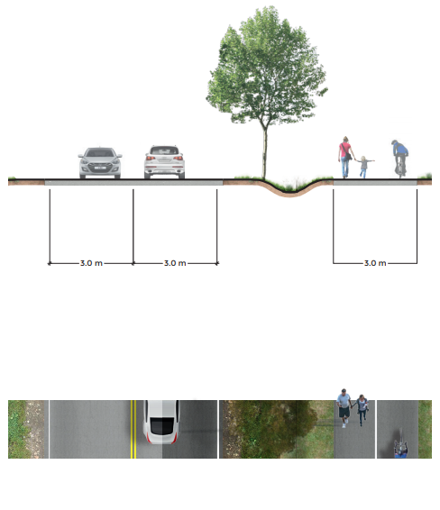
Multi-Use Pathway
Multi-use pathways are similar to separated multi-use pathways, but are not within the road right-of-way).
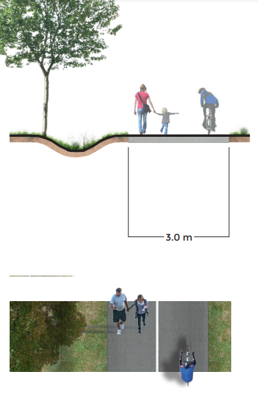
Pedestrian Trail
Pedestrian trails are basic trails that are narrower than multi-use trails and are too narrow or steep to accommodate bicycles. They can be used by pedestrians, cross country skiers, or snowshoers.
Amenities and Placemaking:
A well connected and organized network of active transportation routes will certainly help accomplish many of the goals of this Plan. Beyond this, however, the Town can further encourage active transportation use by providing support services and amenities, such as bike racks, boat launches, picnic areas, benches, equipment tools, maps, wayfinding signage, and more. These types of services and amenities can help make active transportation more attractive, convenient, and comfortable.
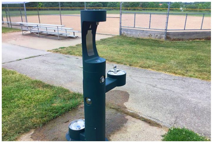
Water Stations
Water and hydration is a necessary component of any physical activity, and active transportation is no exception. Water fountains and bottle filling stations to active transportation users are the equivalent to gas stations for cars.
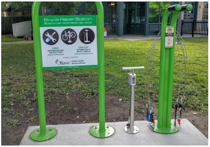
Bike Repair Stations
In order to encourage cycling through the Town, a handful of maintenance tools for bicycles and other recreational equipment, such as screwdrivers, wrenches, and pumps could be provided at a few traffic locations.
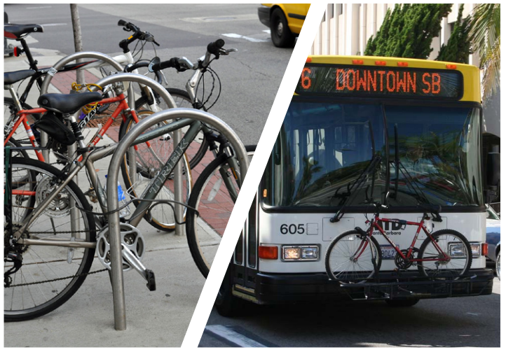
More Bicycle Racks and Transit Racks
Bike racks allow cyclists to use their bikes for everyday trips. Priority locations for bike racks are based on common destinations and key junctions in the active transportation network.
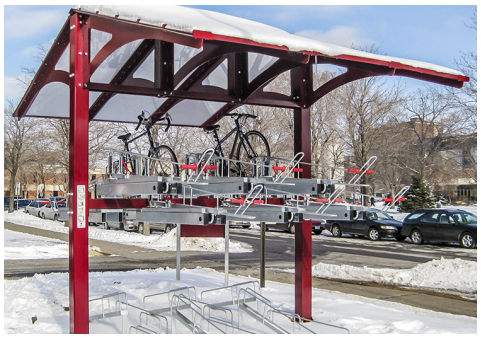
Sheltered Bike Parking in Key Locations
Cyclists identified a need for both increased parking and protection from the elements. Larger scale sheltered bicycle parking should be provided at major employment centres, schools, and in the downtown. This will improve cycling conditions through all seasons, allowing cyclists to travel without worry of weather changes and minimize maintenance costs. Not only does this implementation cut costs for cyclists but residents will be more willing to cycle and more comfortable cycling if they have appropriate accommodations.
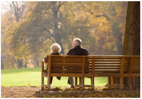
Benches and Street Furniture Along Trails and Streetscapes
In order to improve the accessibility of Kentville’s trails and streetscapes, street furniture and other amenities are needed. People of all ages and abilities will have an easier time walking or cycling through the downtown if there are places to stop and rest and/or offer protection from the elements. These spaces will reduce stigma associated with “loitering” often placed on marginalized groups, and instead support the public use of public spaces.
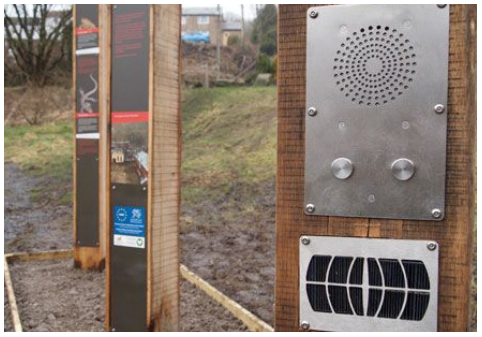
Signage and Placemaking
Placemaking initiatives encourage the public to interact with their surroundings through playful or artistic design interventions. Promoting health and happiness through the built environment can make active transportation more enjoyable to both locals and visitors alike. Building on the community’s assets and inspiration, these interventions will be best accomplished in partnership with the community.
The Harvest Moon Trailway as a Platform for History and Interpretation
Kentville has an interesting and unique natural and social history. The Town could consider creating and updating interpretative planning signage along the Harvest Moon Trails that highlights the natural environment and history of the place.
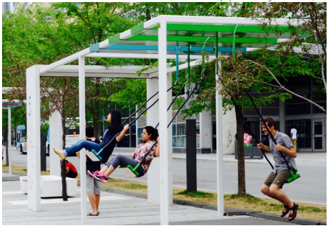
The Harvest Moon Trailway as a Platform for Play
Play has been proven to stimulate creativity, release endorphins, improve brain functionality, and can help keep us feeling young and energetic. The Town can easily create a practice of play in the lives of its citizens by providing some urban "interventions" in public spaces that encourage imagination and creativity.
The Harvest Moon Trailway as a Platform for Public Art
Similar to play, public art can enrich a community through its ability to humanize the built environment, ignite imaginations, encourage thought and to prompt community conversations. Public art can also benefit the community by improving the sense of place and can be used as a tool in economic development. The Harvest Moon Trailway could work with the local art community to develop outdoor installations that could be implemented over time.
Decision Signs
Decision signs provide directions to destinations ahead of intersections to provide cyclists the time to make appropriate wayfinding decisions. Decision signs should be located at a safe stopping distance before a decision point (ie; a junction or intersection along a bicycle network).
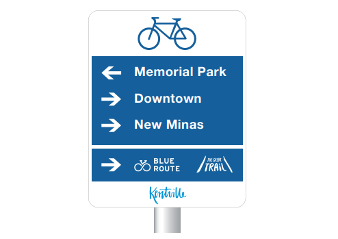
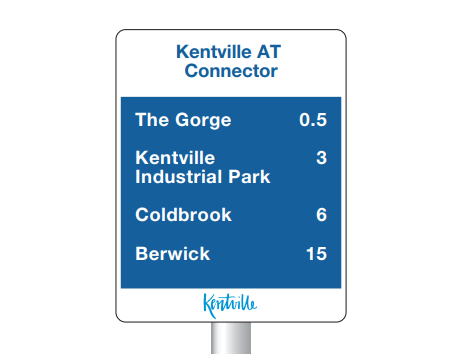
Confirmation Signs
Confirmation signs provide information about upcoming destinations and also help assure cyclists that they are on the right route to their intended destination. Confirmation signs are located after important decision making points along a bicycle route. They help confirm that cyclists have made a correct turn or movement and are on the correct path to their intended destination.
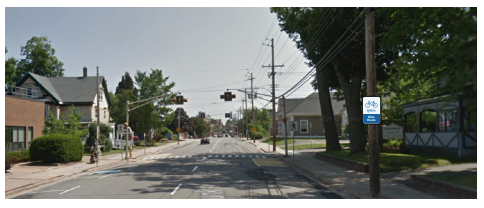
Street Name Bike Route Signs
Kentville has adopted customized street name signs that incorporate the Town's new brand and identity on them (see top left). A proposed alternative to the standard street name signs is one with a bicycle on it to indicate that the street is a designated bike route (see top right).
Bike Route Sign
Bike Route signs should be places along designated bike routes throughout the Active Transportation Network. In some cases, directional bike route signs may be required to keep cyclists on the proper route.
Bike Route Directional Sign
In some cases, directional bike route signs may be required to keep cyclists on the proper route.
Share the Road Signs (MUTCD)
A standard TAC approved share the road sign is used to warn motorists that they are to provide safe space on the road for cyclists and other vehicles. This sign also warns motorists and cyclists to exercise additional caution on the upcoming section of road.
Share the Road Signs (Alternative)
The typical share the road sign is taken from the Manual for Uniform Traffic Control Devices (MUTCD), however, many people find that the sign is not effective and does not communicate the amount of space required to give cyclists on a shared road. By law, motorists are required to give cyclists a minimum distance of one metre when passing them. The alternative sign proposed above communicates this more clearly than the standard MUTCD sign.
Implementation of the AT Plan
The identification of priority areas for this Active Transportation Plan is a key component of our equity principle. These areas include communities which serve vulnerable residents or benefit a high density of people when measured either through population or traffic.
- Downtown: The downtown is used by all residents, commuters and visitors to Kentville, and the trail gap has been identified as a priority throughout this process.
- North End Kentville: This neighbourhood has some of the highest densities in Kentville but comparatively less access to trails and recreation. There are concentrations of vulnerable populations in this community, and sidewalks and roads are in need of maintenance and connectivity
- The Recreation Complex: This area is both a recreational destination and a school zone. This key destination was selected to prioritize youth and encourage active transportation, building on existing assets.
- Kentville Business Park: This major employment centre also contains a host of government services. Though a key destination, this area is currently inaccessible for active transportation users.
- Valley Regional Hospital: Public engagement showed a need for improved routes to and from the hospital, connecting it to downtown and the surrounding residential areas. Improvements in this area will affect hospital employees, patients and visitors throughout the town and region.
For all the details of the Active Transportation Plan, click here!
This project was funded in part by the government of Canada, and the province of Nova Scotia.